

2016 Trips

 1
1

December 26, 2016

Peavy Arboretum
4 miles of hiking • 500' elevation gain •
Quick trip to Peavy for a short hike with my best friend.
December 3, 2016

Triangulation Peak
6 miles of hiking • 1000' elevation gain •
Took my friend up to Triangulation Peak for a quick morning hike in the snow. Not much on road to TH at the time, but guessing TH is covered now. Did not go down to Boca on this trip.
November 20, 2016

November 12, 2016
 3
3
Wahkeena, Multnomah Basin, Nesika Loop
12 miles of hiking • 2750' elevation gain •
Finally got out for a solid jaunt with my bestie last Sunday. Did an extended loop around Multnomah Falls. Up Wahkeena heading towards Devil's Rest, going off trail a bit to the basin and on down to Nesika and the ornament trail. Was a seriously much needed outing that I am feeling a bit with how bad of hiking shape I'm in these days.
November 6, 2016
 1
1
Marion Lake-Marion Falls
6.5 miles of hiking • 1000' elevation gain •
Took my friend up to Marion Lake - Marion Falls for a quick Saturday hike. It's been a crazy few months and I have not gotten out much so this trip felt really good. May have only been a few miles but to just get "out" in the woods again, felt fabulous!!
October 22, 2016

Davis Bayou
2 miles of hiking • 0' elevation gain •
Went to Davis Bayou while out in Mississippi visiting my son. Short little stroll, saw a box turtle meandering around the trail, a juvenile alligator, and an adult alligator. I saw the adult resident one 4 years ago when I went and let me tell you she got much bigger. Sadly the ranger said folks are feeding her. Some people are not very bright. She now comes very close to the viewing platform and there is nothing keeping her from coming up on land. This isn't a zoo or anything so she isn't contained.
September 22, 2016

Drift Creek Falls
3 miles of hiking • 500' elevation gain •
Did a short, quick hike at Drift Creek Falls to relax me before my trip out to the east coast. Later in the day, not too many people out. I picked the perfect spot that day.
September 15, 2016

SILVER FALLS SHORT LOOP
3.5 miles of hiking • 500' elevation gain •
Quick closed to home,after work hike with my son who is at home visiting. :)
September 9, 2016

Clear Lake
4.5 miles of hiking • 250' elevation gain •
Took a solo day road trip. Stopped here for pictures and decided to enjoy the lake loop. Great stroll!
August 21, 2016
 3
3
Jefferson Park Via Whitewater
13 miles of hiking • 2250' elevation gain •
After my Diamond Peak fail, I decided I must start getting back out and hiking again so picked a favorite of mine Jeff Park. Was a beautiful, sunny day with a light breeze that kept most of the hike really cool. It didn't start to warm up too much until about 1 pm when we started our hike out. Fantastic day, slightly dampened by all the SAR in and around the area searching for the 21 yr old that went missing last weekend.
August 6, 2016

Diamond Peak (fail)
10 miles of hiking • 2750' elevation gain •
So a bit on yesterday's climbing fail for me. I had driving directions to trailhead but not much of a map so I went to google put in the trailhead, double checked it was right by looking basecamp and printed the map and directions. Sadly google failed me for the first time (google's directions were no where near Sulivan's directions) The last 7 miles of road were hell, and i do mean that literally. They were meant for offroading and I'm not sure how my car even made it through some of the stuff (the last mile was an old wagon road)!! One of our hiking partners did something similar and ended up on that same road in a little Toyota which sits 3 inches lower than my car. I'm even more surprised she made it through. Anyone wanting to do some serious 4 wheeling, just let me know, I have the perfect road for you! (photo is good idea of what it was like, just add some deeper ruts) By the time I got to trailhead, my head was pounding from the stress and anxiety (I was in near panic attack that whole section) of the last hour of driving, was 40 minutes later than planned. Rushed 2.5 miles to meet up spot. My anxiety finally cleared up but the headache remained. The mosquitoes were swarming so bad we all had head nets on. So by the time we started climbing I was not feeling well at all, between the headache, and heat i was becoming nauseated and called it quits, sending my group on up. For those that know me well, know that stopping a hike is not something I do and to do so is incredibly frustrating for me. I will be going back and finishing what I failed at miserably yesterday. Up note of day, I got to hang with some great people and the more climbs I do with the Chemeketans, the more I love being part of this group. And I had the fabulous bike ride to end the day. All in all it could of been worse and I learned a valuable lesson. Always double check my driving instructions.
July 30, 2016

Silver Falls Short Loop
3.5 miles of hiking • 500' elevation gain •
Quick closed to home,after work hike to get outside and in nature. 2nd trip in 3 days.
July 25, 2016

Silver Falls Short Loop
3.5 miles of hiking • 500' elevation gain •
Quick closed to home,after work hike to get outside and in nature.
July 22, 2016
1
Hiking in and of climbing spots at Smith
4 miles of hiking • 0' elevation gain • 1 night
Spent weekend at Smith climbing agian.
July 16 – July 17, 2016
 1
1
Hiking at Smith Rock. To and from climbing spot.
4.5 miles of hiking • 250' elevation gain •
More hiking in and out to climbing spots. Mark was lazy and made me take the long way to the spot as opposed to climbing over Asterisk's Pass. I'll take the mileage though because my hiking mileage is not so hot this year with my newfound hobby. :)
July 9, 2016

Hamilton Mountain
8 miles of hiking • 2250' elevation gain •
I have climbing fever but have been missing hiking so took a quick jaunt to a near by favorite hike that would make me climb a bit and whine a bit lol.
July 3, 2016
 1
1
Hiking to climbing spots at Smith Rock (My second home lol)
1.5 miles of hiking • 0' elevation gain •
June 26, 2016

Temple Lake and Marion Mtn.
10 miles of hiking • 1500' elevation gain •
Did this lovely hike taken from Matt Reeders 101 Hikes in the Majestic Mount Jefferson Region. Not a bad way to spend a Sunday, however some notes. The good: Had the hike to ourselves. Only saw two people coming off Marion Mountain summit the entire hike, other than that not a soul to be seen. Its a fantastic viewpoint with an easy grade to get to. No huffing and puffing to get an amazing view! The bad: Other than the lake and the viewpoint, there isn't a whole lot to see on this hike, though that's not always a bad thing but if you are looking for a hike with tons of views, you might want to look elsewhere. Mosquitoes were a pain before we used off. Highly recommend you bring your repellent whatever you use. Okay now onto the ugly: the blow downs. Wow there were tons of them and I do mean tons. Easy to get around or over but plan on adding time to your trip because they will slow you way down. Gotta say though, that view! Worth it.
June 19, 2016
 1
1
Hiking to climbing spots and Misery Ridge Smith Rock
4.5 miles of hiking • 1000' elevation gain •
Rock Climbing is becoming a small obsession. I imagine I will get some more hiking mileage at Smith this year.
June 16, 2016

Hiking to climbing spots at Smith Rock
2.5 miles of hiking • 500' elevation gain •
hiking mileage to two different climb spots at Smith Rock State Park
June 1, 2016
 1
1
Ape Canyon to Loowit Falls
21.5 miles of hiking • 4500' elevation gain •
Had a fantastic day with good trail friends. Took an all day stroll around the amazing Mount St. Helens. Doesn't get much better than this!
May 30, 2016

Whitewater to Whitewater Creek
8 miles of hiking • 0' elevation gain •
Went up to Whitewater with the intention of seeing how far in we could get until it became mostly snow. Got as far as Whitewater creek. Snow started steadily in the talus fields right before the creek. There was on long section at mile 2.5ish that lasted about 1/8th to a 1/4 mile but then cleared out until the talus fields. The snow looked to be steady from the creek on. I confirmed with a friend who also went up today that Jeff park is still under snow albeit melting snow. From the photo I saw, Scout Lake looked to be starting the melting phase.
May 29, 2016

Triangulation Peak/Boca Cave
5 miles of hiking • 1000' elevation gain •
Had a quick trip up to Triangulation Peak. Patched of snow to content with mostly at beginning and then steadily at the end. Boca Cave was clear to get down to.
May 28, 2016
 1
1
Smith Rock Hike into and out of climbing areas
3 miles of hiking • 750' elevation gain •
Did some rock climbing out at Smith Rock State Park this weekend for the first time. Only did a few miles of hiking into and out of the spots where my group climbed.
May 14, 2016

Silver Creek Falls - Short Loop
4.5 miles of hiking • 750' elevation gain •
Did a short 4.75 mile trip around part of Silver Falls after work to relieve stress. It's my go to close to home spot for those times that I don't have much time.
May 10, 2016
 4
4
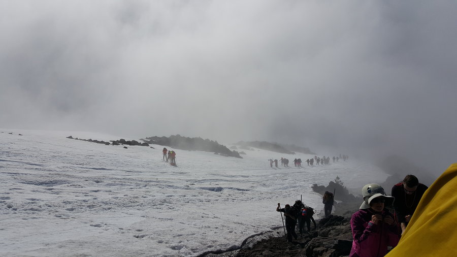
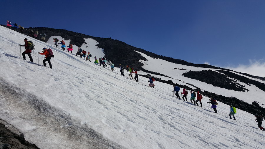
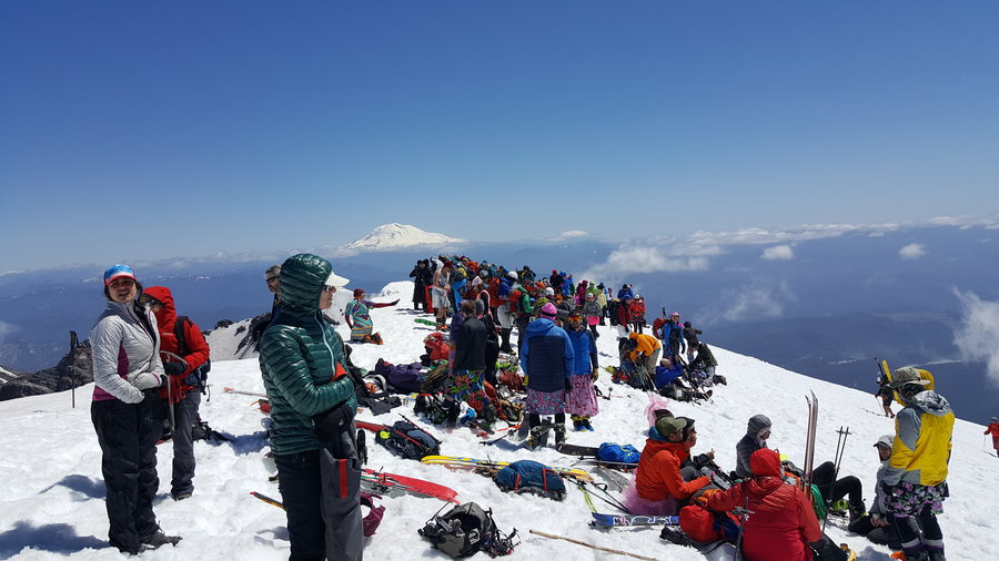
Mount St. Helens Worm Flow Route Mothers day
11.5 miles of hiking • 6000' elevation gain •
I got the opportunity to climb Mount St. Helen's via the worm flows route (not my favorite but wasn't so bad this round) on Mother's day and jumped on it. Talk about crazy busy, but in all honesty it was so much fun that the crowds didn't bother me for once. Day started off cloudy and drizzly but as you can tell from the pictures, once we broke through the clouds, it was nothing but blue sky and wide open views, if albeit a tad windy. The wind actually made the hike even better, it kept the sun from overheating us and the snow. Best part of the hike? Glissading 3k feet of my descent lol. So much fun!
May 8, 2016

 1
1
Wilson River Trail from King's Mtn TH
5.5 miles of hiking • 1500' elevation gain •
Took a short jaunt on the Wilson River Trail today. Was thinking a nice low elevation, river hike on a rainy day fit the bill, except for there was no river and it had quite a bit more elevation than I had anticipated lol. Isn't that how it usually works though? Tons more out here I want to explore and I anticipate I'll be back here soon to do so.
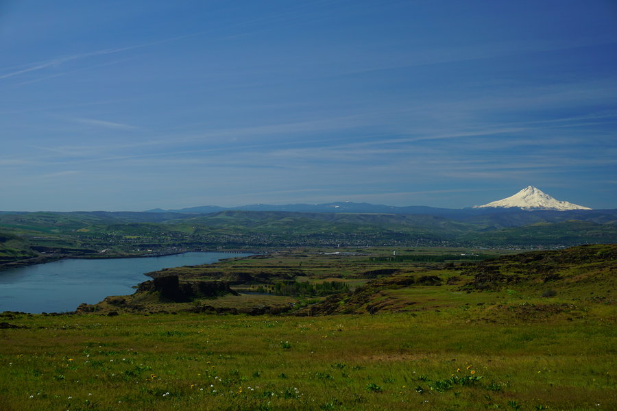
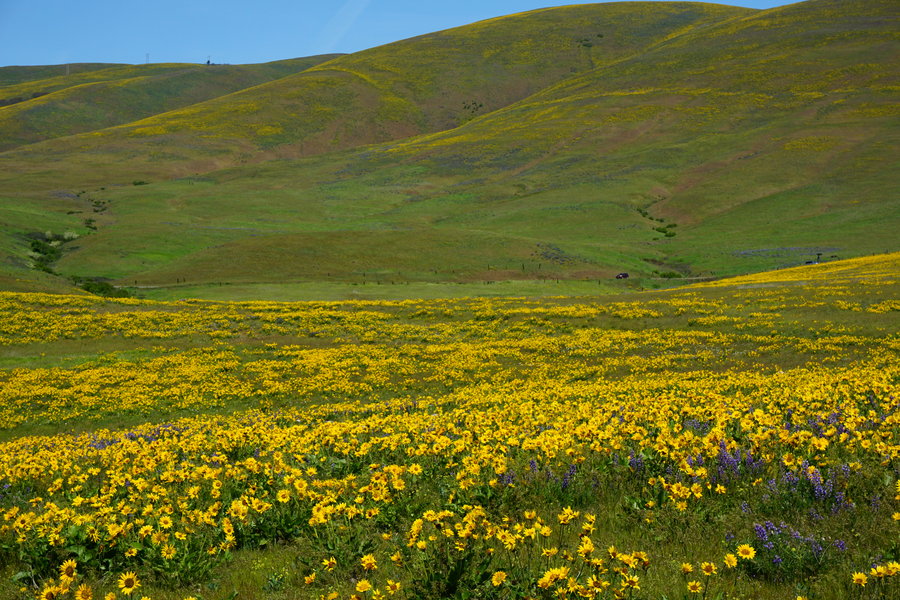
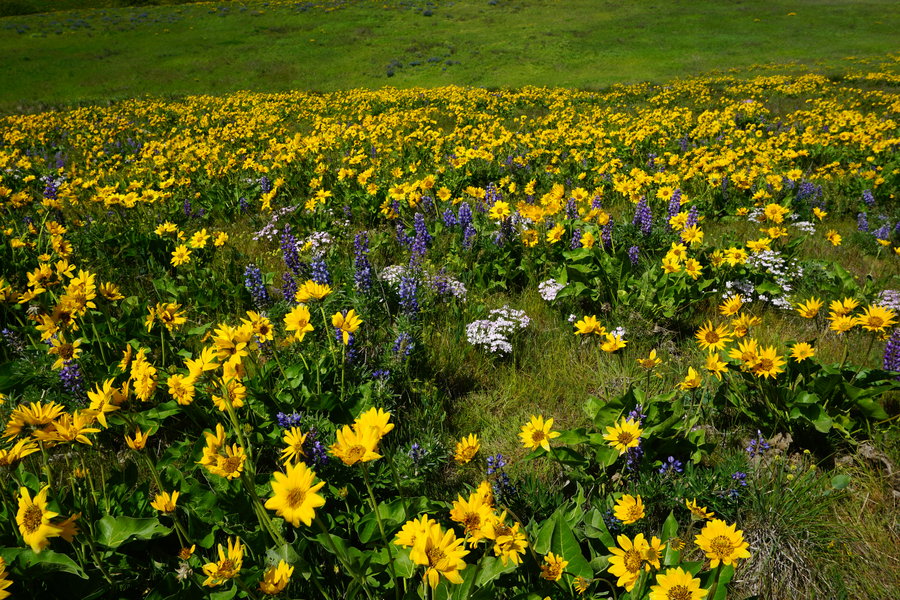
April 22, 2016

Dalles Mountain Ranch
8.5 miles of hiking • 1500' elevation gain •
Went to visit the wildflowers of Dalles Mountain Ranch for the first time. Absolutely beautiful. Busy, but a great day for this hike even if I got a tad red from it.
April 17, 2016

King's Mountain
5.5 miles of hiking • 2750' elevation gain •
This is a calf burner of a hike and I really needed one. What I did not need was the vertigo episode to happen this morning. I have been suffering with it for a month and it really showed it's ugly head today. Cancelled my plans of doing the full loop. The Backside of King's is very steep and was wet and slippery. Decided best not to try that while I wobbly. Now I have a great reason to go back and do the full loop!! Only saw a couple of folks going up but on the way down around noon, ran into several sets going up.
April 10, 2016

Henline Falls
2 miles of hiking • 250' elevation gain •
Wanted something close by that I could trail run. Opal Creek was destination however the roads were awful so stopped and did a quick 2 miler at Henline Falls.
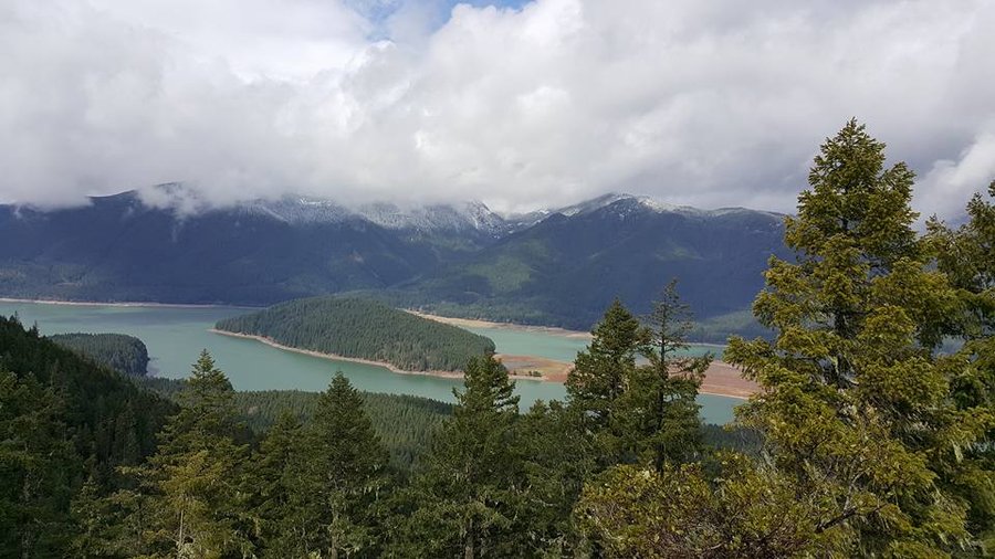
April 3, 2016

Coldwater Wander
9 miles of hiking • 2000' elevation gain •
Planned to snowshoe up by Coldwater. Ended up carrying them the whole way. Went up past the equipment and then did some wandering in the area.
April 2, 2016
 1
1
Stahlman Point
4.5 miles of hiking • 1250' elevation gain •
Finally got a small hike in. Plan B backup hike. Stahlman Point. Marion Lake needs snowshoes (didn't plan thoroughly enough), and they had a search and rescue happening (found safe thankfully).
March 27, 2016

 1
1
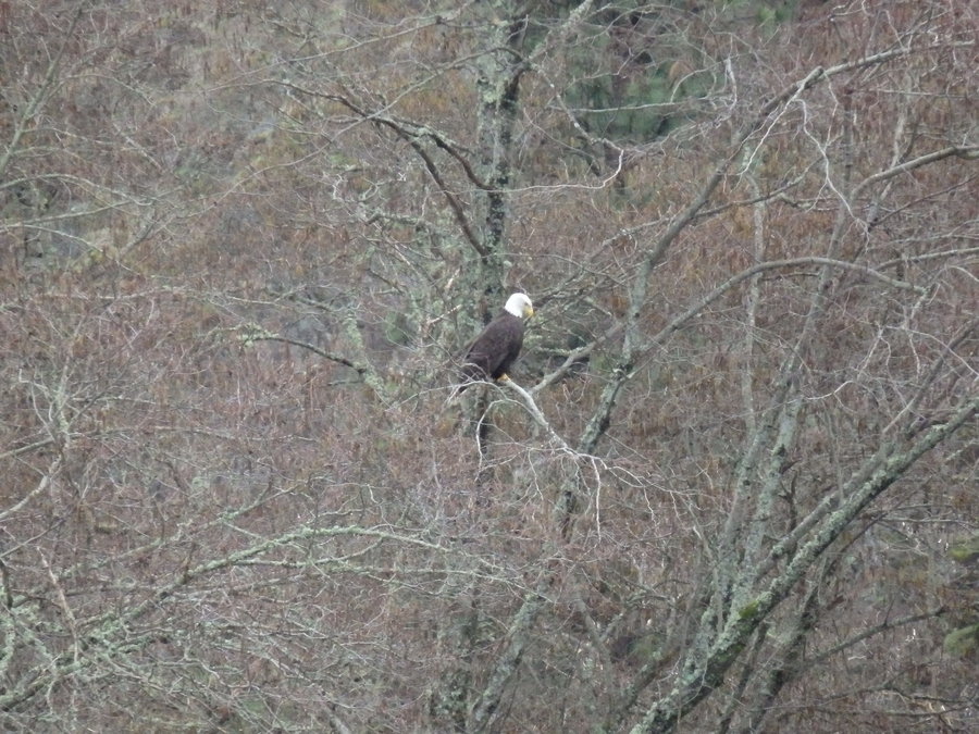
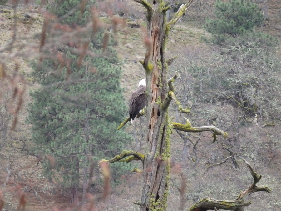
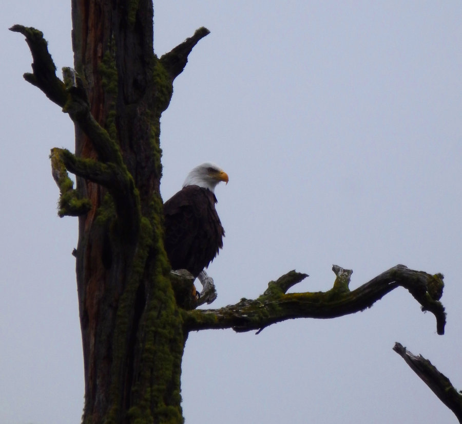
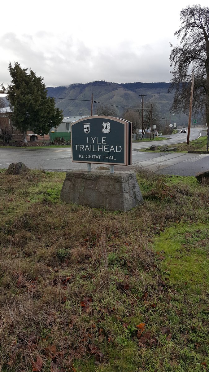
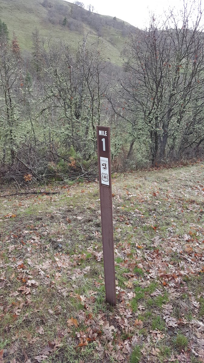
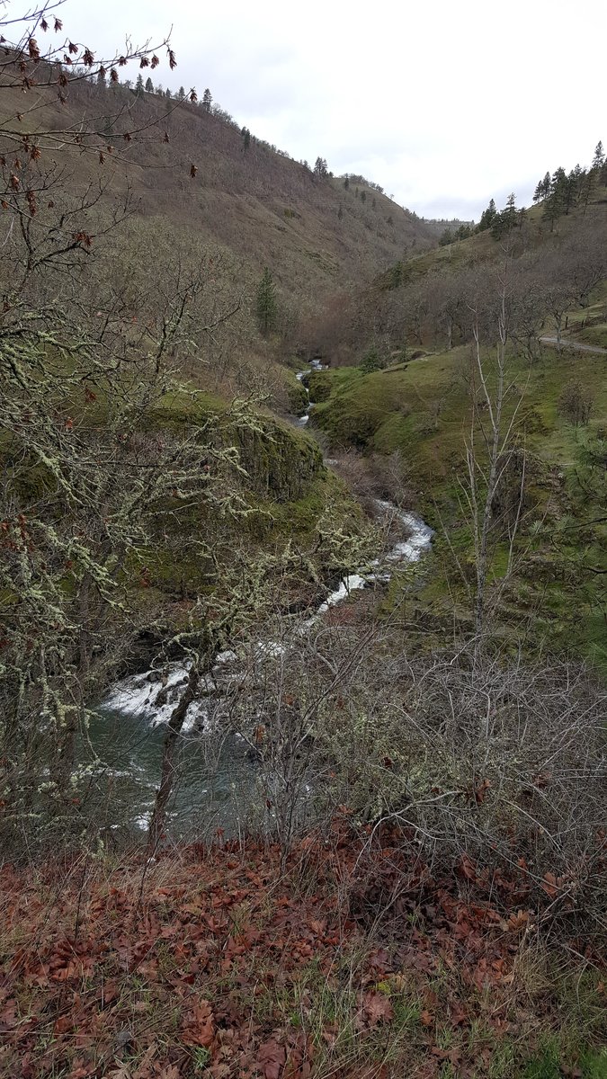
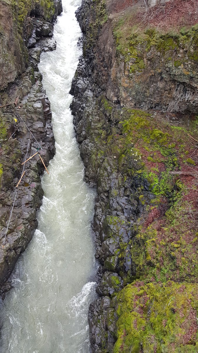
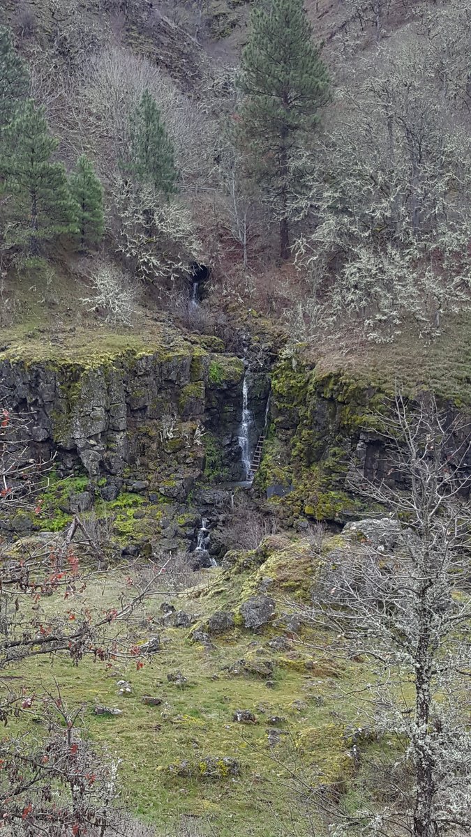
Klickitat Rail Trail
10 miles of hiking • 250' elevation gain •
Did 10 miles on the Klickitat Rail Trail from the Lyle Trail head. First time on this trail. Have to say not my favorite of trails I have been on. Don't care too much seeing 142 and traffic while I hike. I tend to like things a bit more secluded which is why we turned around at mile 5. Next time I think I will check out Swale Canyon and hike down that way. Might be more to my liking. However with that said, I have to say that seeing the Bald Eagle made the trip 100% worth it. Something so majestic about that bird!
February 27, 2016

 3
3
Deschutes River Trail to Harris Canyon
26.5 miles of hiking • 1000' elevation gain •
After reading Karl's trip report from a few weeks ago, I just had to get back out here. Yesterday's forecast was partly sunny with no rain and that beat any potential soggy weather on the westside. We got sun in the morning and clouds in early afternoon then back to sunny sky's as the afternoon wore on. Decided once we got to the homestead that I was too close to my last day hiking goal of marathon mileage so we pushed on and took a side trip up a trail into Harris Canyon getting the extra mileage needed to end the day at 26.26 miles! Let me tell you, the last 6 miles was rough, my left hip had been giving me fits since the homestead and was getting pretty sore by this point and all I really wanted to do was go stick my tired, sore feet into the river but sadly no time. We made it back to the car about 15 min past sunset. Having averaged a pace of about 3 mph all day long. So glad to have made my final day hiking goal! I don't think I will be doing many of these and if I do again I will likely do them in the summer when the days are much longer lol.
February 6, 2016
 1
1
Maxwell Butte Sno-Park (south Maxwell Shelter and Mtn View Shelter)
8 miles of hiking • 1250' elevation gain •
Went back out to Maxwell Butte Sno-Park and visited the areas shelters, South Maxwell and Mountain View Shelter. What a fantastic day for snowshoeing. No wind and plenty of fresh snow and lightly snowing most of the day.
January 24, 2016
 1
1
Maxwell Sno-Park to Twin Lakes Snowshoe
6.5 miles of hiking • 1250' elevation gain •
Did a quick snowshoe up to Twin Lakes via Maxwell Sno-Park. Just getting the feel for snowshoeing.
January 10, 2016

South Coldwater Snowshoe
5 miles of hiking • 1000' elevation gain •
Took our first snowshoe trip to South Coldwater Trail. Unfortunately had to cut the day short about a 1/4 to 1/2 mile away from the equipment. The sustained winds were bad enough to knock Mark over and make me have to sit down to avoid being tossed down the hill. Regardless, we had a blast for our first time snowshoeing!
January 2, 2016
